Monday, May 30, 2011

Bakersfield, CA

Today was a travel day.
We hit the road at 0730 this morning and drove 460 miles to Bakersfield, CA.
This puts us just 3 1/2 hours from our next object of interest - Sequoia National Park.  We will make the drive to there tomorrow.

Today we drove thru Sandstone deserts that gave way to white sand desert - interrupted only for a short while by the surreal "splendor" of Las Vegas.

We finished the day coming over Tehachapi Pass and descending into the San Joachim Valley - one of the most productive farm areas on the planet.

The Tehachapi pass is famous for the Tehachapi Loop.

The Tehachapi Loop is a .73 mi long 'spiral', or helix, on The Union Pacific Railroad through Tehachapi Pass, in south central California. The railroad line connects Bakersfield in the San Joaquin Valley to Mojave in the Antelope Valley. The loop takes its name from the circuitous route it takes, in which the track passes over itself, a design which lessens the angle of the grade. The loop gains a total of 77 feet in elevation as the track ascends at a sustained 2% grade.[1] A train more than 4,000 feet (1.2 km) long (about 85 boxcars) thus passes over itself going around the loop. Today, the railway line, with almost 40 daily trains on average, is one of the busiest single-track mainlines in the world.

This is a photo of a train passing over itself on the loop.

We are now settled into the Orange Grove RV Park just outside of Bakersfield.  It is an RV Park that was built in the middle of......   an orange grove.   We are surrounded by orange trees.   Too bad it is not orange season.  

Till tomorrow and Sequoia.

Sunday, May 29, 2011

Zion Day 2

Day 2 of our Zion adventures started with an early morning drive on the Zion-Mt. Carmel Road.  


One can take this road into the park from the east (we chose to take the longer route around) however it is narrow, steep, and requires an escort thru the tunnels since they were constructed in 1930 before trucks, and campers, where as tall as they are today.  In order for us to pass thru the tunnel we would have to drive down the center line or else we'd hit the sides of the tunnel with the top of the trailer.


Along this road you pass many interesting geological formations, but one of the most interesting is Checkerboard Mesa.


It is formed first from layers of sediment that were laid down, each layer was slightly erroded causing the horizontal lines....   Then as the layers were compacted over the eons - vertical expansion cracks formed. These cracks, once exposed, were then subject to further erosion which caused the relief.

After our round trip drive on the Zion-Mt. Carmel Road - we returned to our campground  (I use that term very loosely) to hook up the camper and move into the National Park where we are camped for tonight.  

Once settled in we were off hiking again - this time we took the dogs on a 4 mile hike along the Papyrus Trail which runs along side the Virgin River.


We stopped to do our self portrait for the day and as soon as we did, both dogs jumped up in our laps so todays has the furballs in it as well.


Now that we are back to the camper - the Doods are worn out.  I think they will sleep till tomorrow.  

Tomorrow we pick up once again and head out across the Mojave Desert, our next destination Sequoia National Park.   It is a 10hr drive from here so we will break it up into 2 legs.  I have a few places that we could stop but most likely we'll go 7.5 hrs to Bakersfield California.   This would place us 3 hours or so from Sequioa.


Until then - to all of my fellow Veterans


Semper fi

Honor, Courage and Commitment


Saturday, May 28, 2011

Zion Wow!

Today we made the 150mi trek over to Zion National Park.  We arrived at the campground at 12:30 right on schedule.   We are staying one night in a private RV park just outside of Zion, and tomorrow we move into the park for one night.

After we arrived I started cracking the whip and told Kate to Hop on the Bus Gus.  
There is a free shuttle bus service that takes you from town into the park, then another set of shuttles that take you up into Zion Canyon.  The shuttle bus system was put in place in 2000 to alleviate congestion and protect the environment.


For those of you who might not know, the road up Zion canyon is a short six miles that dead ends when the canyon narrows down to as narrow as 6' in parts.

I remember coming here in years past and it being one big 6 mile long parking lot....  But not anymore.  The propane powered articulating buses run every six minutes!

Zion is a hikers park and today that is exactly what we did.   
We put in about 10 miles of up this mountain and down the next.  
We visited emerald pools clinging to the side of sandstone cliffs and hanging gardens of green foliage in the middle of a desert.


We hiked under waterfalls and when the wind shifted we received a refreshing bath.  Soon after, the dry air evaporated our clothes in minutes giving us a great cool down.


By the time we got back to the camper it was time for a quick shower - feed the doodles - then off to a wonderful dinner at an outside cafe - topped off with a couple of double expressos.  

We just got back to the camper now (915pm) and we are dirt tired.   I just don't have the energy to do all the photo work tonight so this narration will have to do till tomorrows post.

Tomorrow morning we are first off to drive the Zion Mt. Carmel road, then back to the camper to move it into the park, then more hikes to round of the day.   Somewhere in there I also have to find the time to run payroll for my company.


We have a lot of pictures and believe me - this place is awe inspiring.  Hopefully there will be some that capture the beauty of this place.

We'll see tomorrow for sure.

From a very beat Greg, Kate,  & the Doodles.


LATE UPDATE:

As you can see - I worked thru the "pain" and posted some photos real quick.

Now I gotta hit the sack!

Friday, May 27, 2011

Good by Grand Canyon - Hello Zion!

Day 2 our final day at Grand Canyon North Rim turned out to be another day of beautiful sights and beautiful weather.

After a couple of hours of phone meetings for work, followed by some computer time - we eventually headed out with the Doodles for a 3 mile walk along the bridle path to the North Rim Visitor Center and back.

Back to camp we dropped the monsters off and headed out to Cape Royal.  Before we did however it was time to take advantage of some sweet fuel prices.

When we left NC, Diesel was costing me $4.09/gal.  The best prices I found so far was about $3.87 in Texas and Oklahoma.  Once we got out to Utah & Arizona where it is way way far between towns the prices shot up to around $4.35.

When we got to the North Rim I had only used 15 gallons of my 50 gallon tank and I figured the fuel price here would be even higher but was pleasantly surprised to find the price to be $3.66. 
And that included the full-service treatment by Walt the fuel guy from Alaska.  


It turns out that this is very early in the season for the North Rim and they have not ordered fuel yet this season so we got to take advantage of last years prices.   A little extra Diesel Additive (I don't leave home without it) and we saved ourselves $10 on the 15 gallons  

 I was just informed by a reader in Beaufort that Diesel is down to $3.79.  Thats a $.30 drop in 2 weeks.  Maybe I wont have to get Kate a job to pay for our way home after all.


Our trip out to Cape Royal shows the colors found in the canyon are quite varied.

Greens & Reds & Shades of brown...


Desert Pastels...

In the distance is the "Painted Desert"  the sand there is all the colors of the rainbows.


How many colors can you find in this picture?


The Colorado River is less visible from the North Rim.  Here in the center of the photo you can spot it down at the bottom of the canyon.   Still doing its canyon building - albeit at a slower pace due to dams and flood control.


Does Kate look like she's enjoying the Canyon?


Finally our self portrait of the day


Tomorrow we pick up roots once again and head on down the road.

Our next stop is Zion National Park in Southwest Utah, 150 miles and 3 1/2 hours further west.  

On the way we pass thru the twin cities of Colorado City, Az and Hinsdale, Ut.  
Both are famous as being the former home of Warren Jeffs the convicted polygamist.  The towns are mostly polygamists and Kate can't wait to drive thru.   

I've warned her that if she doesn't behave herself I might just dress her up in a Prairie Dress and toss her out on the way thru town.....  I can't repeat here what she said to that :-)

T - I promise to try and keep up on my game and not let you down!


Thursday, May 26, 2011

Grand Canyon & it's a small world

Today we made the 2 1/2 hour drive from Lake Powell to Grand Canyon.

One thing that I've always enjoyed about driving in the West is that usually - if you don't like the scenery - just keep driving....  It will change soon.

Today was an illustration of that concept.

Our drive started out in the red rock desert.


In a short while we started the climb from 4,000' altitude to the 8,500' foot altitude that we eventually attained up here on the Kaibab Plateau where we are camped along the North Rim of the Canyon.

This photo was taken at around 6,500' just a short 1/2 hour after the previous one.


Soon we arrived at the Grand Canyon


The Grand Canyon Lodge


Todays Self Portrait
Picture was taken at the overlook below the lodge


A funny thing happened on the way back up to the lodge....

Just as we got done hiking back up I saw the same group of German Students that I had mentioned in yesterdays blog as having been on the Antelope Canyon Tour with us.

We saw each other and had a good laugh - took some photos - exchanged email addresses etc.


Sometimes the world is a small place.   You might remember last years blog that we kept meeting the same couple in the fancy red painted pickup...?

Anyway - tomorrow we do some hiking and more picture taking.   It's late and I have a 6am phone meeting so it's  time to chill.


Wednesday, May 25, 2011

Upper Antelope Canyon

Another awesome day!

Todays schedule was light so as to give me plenty of time to get work done.   Getting up at 5am I was able to get 7 solid hours in before we hit the trail....   And hit the trail we did!

Our plan was for a mid-day visit to Upper Antelope Canyon.  It is a "slot canyon"  a deep narrow canyon carved by flash flooding out of sandstone.   The walls are polished over the eons by those flash floods.  The sunlight has a difficult time penetrating the depths and that is why we selected our 1pm tour time.  The sun would be high in the sky and allow the rays to penetrate the depths.   We were not disappointed.


DON'T FORGET TO CLICK ON THE PICTURES FOR A FULL-SIZE VIEW!

Throw a handful of sand in the air then snap snap snap


Kirk to Enterprise - 3 to beam up.


We have hundreds of photos.  One more surreal than the next.  All I can say is what a place!

Antelope Canyon - both upper and lower canyons - are on Navajo Land and you may only visit them as part of an organized tour.  In 1997 before tours were mandatory - 11 tourists were killed in in a flash flood.  To get there and back you and 11 of your best friends get to ride on these desert party busses.


Picture about 10 of them racing and bumping across the desert and you get the picture.   We were the only Americans on our group of 12.   Several were young German College students from Kansas City who were traveling to California and back by car - in a week and a half!!  A couple of other young ladies were Chinese college students from Illinois.  Rounding out the group were a few people from France.  It was so nice to be a part of this multi-national bunch - all here just to enjoy the wonders of nature.

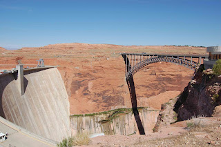
On the way back to camp we stopped at the Glen Canyon Dam.   This dam holds back the Colorado River forming Lake Powell.  (Lake named after Kates best friend Mary)

This is the dam - picture taken from the bridge over Glen Canyon.


This is Glen Canyon - looking downstream from the bridge

Here is the dam with the bridge in the background.


Tomorrow - sadly we pick up roots and head to another hole in the ground....   A little ol place called Grand Canyon.  See you then.


Tuesday, May 24, 2011

A visit to another world

Today we drove 310 Miles from Dead Horse Utah to Wahweap National Forest Campground on Lake Powell just outside of Page Arizona.  Here is todays route map.   We have some where over 2800 miles on the tripometer so far.   I forgot to look at the exact tally.  The truck turned 10,000 miles yesterday.  I'd say the diesel is starting to get broken in.


I chose todays route to take us south on US 160 thru the Monument Valley which straddles Utah and Arizona.   It is one of the coolest places I've ever driven.  The photos below were taken at point B on the above map.

Lonely Planet


This stretch of road runs along the Monument Valley Navajo Tribal Park which is the Navajo version of a National Park.  The Monument Valley has been used in many western films & was a favorite of director John Ford who shot several John Wayne films here including Stage Coach & The Seekers.


Monument Valley was also used in 2001 a Space Oddessey and is also at the beginning and the end of Windtalkers.  (great true WW2 war film if you never saw it)


This last photo is inside the tribal park & was not shot by me.


Heading further south and then west in Arizona we continued to cross some very desolate and sparsely inhabited country.  Along the road however we did spot a few characters.   This guy we had to pass because I was afraid he might start losing parts in front of me.


Finally we arrived at our home for tonight and tomorrow.

Here is the view from our camper.  I spent a few hours working tonight with that as my view outside the window.  That is Lake Powell in the background.


Here is our site


It is a National Forest Campground but really has the feel of a resort.  I continue to be amazed at what a great job all the Federal Agencies do with our National Lands.....  A case study of where government does a great job.  If only we spent a tenth on our parks as we do on the Military.

Lastly - todays self portrait.  
We crossed a lot of open range today (unfenced land where cattle can walk on the road) and when you go from open to closed rangelands you always cross a cattle grate in the road.  Its something that the cattle can't cross but cars can.  When you cross it the tires make this rumbling sound that sends Gracie into red alert.  She starts panting and shaking.    This was her snuggling up with Kate after we crossed a grate.  Lucy is still in the back seat (the doodle nest) just chilling and enjoying the ride.


Tomorrow we are going to visit some of the slot canyons outside of Page Az.  If you have never seen photographs of slot canyons you are in for a real special treat.

See you then.


Monday, May 23, 2011

Arches National Park

Before I start tonight - some housekeeping.  Just in case you don't realize it - those of you who receive the email blog digest - if you CLICK ON THE PICTURES IN THE EMAIL - YOU WILL GET LARGER DETAILED IMAGES.....   TRY IT!!

Now to tonights blog:

I wonder why they call it Arches.....


Getting up extra early I was able to get a few hours of work in before we made the 45 minute drive to Arches.  Upon entering the park you drive up a steep road with several switchbacks and enter a different world.   This photo below is a formation called courthouse rocks a few miles inside the park.


We drove deeper into the park (about 20 miles) passing numerous scenic overlooks.  Took way to many pictures (kate had 185 on her camera just today) and eventually arrived at our first trailhead of the day.

We took the 3 mile roundtrip hike to Landscape Arch - the second longest natural arch in the world.  It is over a football field in length.   Along the trail we met people from all over the world:  Korea, France, Germany, and the most foreign country of all - Texas.


My old boy scout training (motto: be prepared) came in handy today.  Even though a short 3 mile hike - I  took a back pack with extra clothes, water, rain gear and umbrella.   Sure enough - even though it was a crystal clear day when we left, on the way back the skies opened up but we were snug in our gear under our umbrella.

Todays self portrait at Landscape Arch


After we hiked back to the truck we drove a short way then parked and hiked up a canyon and found a quiet deserted place to have our lunch.   It was a delightful place to spend a quiet 1/2 hour.


After our lunch stop we continued down the road to our next must see destination - Delicate Arch.  Delicate Arch is a Utah State Icon.   It is on their license plates along with many other travel related collateral.   A short but steep 2 mile or so round-trip hike up some slip-rock led us to this vantage point.

Notice the people below the arch.


We then drove back towards the entrance to the park and took a side road to the Windows Section.  This section is so-named because several of the arches open up to scenery behind them - like looking thru a window.  First stop was a mile and 1/2 hike to North and South Windows.

Just before we arrived - the sky got black & the rain started to come down in buckets.  Soon we were getting pelted by some small hail.  When we got to the trailhead parking, people were running for their cars and getting out of dodge.  All the better for us as the trailhead parking was full - but soon emptied out.  The rain stopped in short order (as it always does in the West) and we and a few people had the area to ourselves.

North Windows


North & South Windows from a distance

This is looking back towards the storm that passed thru


This time of year the desert is so green.   Small flowers are growing in the most difficult locations and after the rain stopped the air filled with the scents of wildflowers for a short time.  What a great time to be here!  In a future blog I will have to post some of the beautiful pictures that I have shot of the flora.

Our next stop was double arch.   If you look closely at the arch on the left - you will see two arches that both join on the left.  (remember to click the picture to enlarge)


Lastly - this guy looked lonely out there all by himself.  I'm not quite sure why - but it held a strange captivation on Kate and she insisted that I get a shot of it.


Need I say more?


Tomorrow we head south to the Monument Valley.  We might drive 3 hours or we might drive 6.  This means we might bed down in the Monument Valley area - or perhaps on the shore of Lake Powell.   Tomorrow we'll know for sure when we arrive.

Aufwiedersehen