Wednesday, September 20, 2017

Stone Mtn BC to West Glacier Mt

Since our last post we've put some additional miles under the bus and its time
to play catch up with the blog.

Leaving Stone Mtn Provincial Park and our wonderful Northern Lights behind, 
we have traveled south back into the US via the following:

1 Dawson Creek, BC  
2  Hinton, Alberta       
3 Banff, National Park
4 West Glacier, Mont  

The map below shows the route and stops.


(Remember to click on the pictures to enlarge them)

Leaving Mirror Lake at the crest of the BC Rockies, we descend slowly out of the Rockies
as we travel westward towards Fort Nelson, BC.

Along the way we again stop for Cinnamon Buns at Testa River.

After Fort Nelson, the Alaska Highway turns southward and slowly we leave the
Boreal Forest behind.

The colors of early fall still peek at us.

Alaska Highway N of Sikani Chief, BC
A 300+ mile day put us in Dawson Creek where we spent the night at the 
Northern Lights RV Park.  
We've stayed here a couple of times before.
Nothing fancy but it works for the night.

The next day we are back on the road southbound to Hinton, Ab

Since we were unable to find a single open campsite for a few nights at Jasper National Park,
we stayed at the Hinton-Jasper KOA about 40mi east of Jasper.

Our route from Dawson Creek to Hinton, took us south from Grand Prairie, on AB 40
AKA the Bighorn Highway.   A scenic and fairly remote route.

North of Grand Cache, the highway travels thru some hilly country and passes
many natural gas processing centers.
The road is quite dirty from the trucks that constantly enter from the dirt roads to the side. 

In dry weather its no big deal, but when it rains - as it did today - the vehicles get
filthy and covered with mud.

AB 40 - Bighorn Highway North of Grand Cache, Ab
South of Grande Cache the road flattens out and you leave the mud and dirt behind.

AB 40 Bighorn HIghway - S of Grande Cache, Ab
We arrived at the Hinton/Jasper KOA covered with mud. 

This KOA has alot of pipeline workers in residence and about 5-6am you would hear all of them
headed to work - most driving diesel pickups.
Since I'm already up working its not a problem.


We made it all thru the Yukon & Alaskan construction zones without a chip in the windshield.
We were not so lucky on the Bighorn Highway however.

A passing truck chucked up a rock and we got a bullseye about the size of a dime.

I repaired the bullseye chip in the windshield the next morning before it had a chance to spread.
Since it cures by UV light,  I needed to shade it from the sunlight 
during the process till it was ready to cure.

Some cardboard and paper bags did the trick.

Chip repair to the windshield

Our last trip to Alaska had me repairing 5 hits along the way so I consider just one to be a bonus.

I found one of the best self serve RV washes ever in Hinton.

The picture below is just one of the 3 bays.
The other two bays also had catwalks on each side, from where you could clean the roof. 
The bays were over 100' long!

Each bay had several power washers and foaming brushes on
both sides so Kate and I were able to each take a side of the bus and get the deed done
in about 20 minutes.

Hinton RV & Truck Wash
Mud removed...   we headed west back into the Rockies heading towards our next destination...
Banff National Park. 

TC 16 Yellowhead Highway headed westbound towards Jasper, Ab
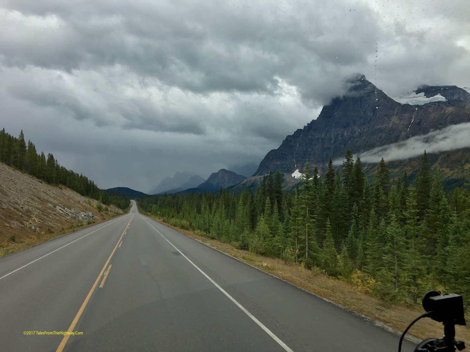
Our route took us south on the Icefield Parkway.
We've done this drive a couple of times northbound and this was our first heading south. 

As we climbed to the Columbia Icefields the environment changed to Alpine
and the colors of the Alpine Fall increased.

Icefield Parkway approaching the Columbia Icefields

Icefield Parkway just South of Columbia Icefield Center
South of the Icefields we again descend to lower altitude into the forest.
Soon a construction stop has us parked for 20 minutes and I got out to stretch
my legs and take a photo of our newly cleaned bus.


Below was our view while waiting for our turn thru the construction.

N Saskatchewan River Headwaters
 Even on a cloudy or rainy day - the view along the Icefield Parkway is magnificent.

Icefield Parkway approaching Waterfowl Lakes area

Icefield Parkway - Waterfowl Lake
 Further south on the IP we approach the headwaters of the Bow River.
The Bow River flows thru Banff National Park and into Calgary, Ab.

Icefield Parkway approaching Bow River Headwaters

Bow Lake and Glacier - Icefield Parkway
 We now spent a week in Banff National Park in an Electric only site.
They have full hook up sites but none were available for a whole week.
It seems all of Canada was taking advantage of the last of summer.

While there -snow started to coat the peaks not far above us.
We even had snow flurries in our campground.

Early Season Snow in Banff National Park
 One of the great things about this RV Lifestyle is the friends that we meet along the way.

When we decided to change plans and head to Banff, I texted our RV Buddies
Rob and Pat who live in BC to see if they could meet us.

Sure enough...  they made the 6 hr drive to Banff and we spent 4 days together.

Having spent a month or so boon-docking on Lake Roosevelt Az a couple of winters ago,
they fell in love with Gracie & Lucy and decided to get an Australian Labradoodle of their own.

So (L-R)  Lucy, Gracie, and Ophelia.
The 3 Doodles get along great!   
You don't even know that three dogs are in the bus!


One neat feature in Canadian National Parks are the Red Chairs.
Strategically placed with a great view...   just find a red chair and enjoy.
Red Chairs Banff National Park
 Kate and I have been making a collection of us sitting in Red Chair Photos 
and now have them from the Maritimes to the Rockies.
Red Chairs Banff National Park
We spent a nice Sunday afternoon visiting the Banff Springs Hotel.
One of the Great Railway Hotels built in the early 1900's by the Canadian Pacific Railway 
along its routes to stimulate passenger traffic.

Banff Springs Hotel

Banff Springs Hotel Reception Lobby

Banff Springs Hotel Restuarant
 The views from all the rooms and terraces in any direction are stunning!

Banff Springs Hotel Terrace View
 Soon our week in Banff was over and it was time to put a bookend on our Alaskan Summer.
Rob & Pat headed to Kimberly and we headed back to the US.

Leaving Banff I took a picture of Rob leading the way out of the campground.

Banff Tunnel Mountain Road
 We first headed north on TC 1 to Castle Junction, where we would catch
Route 93 west, then south.

Trans-Canada Highway 1 Approaching Castle Junction Ab
 The drive thru Kootenay National Park which adjoins Banff NP is beautiful.
This whole immense area of the Canadian Rockies is just stunning!
There are 6 National Parks in about a 40 mile radius in this area.

AB 93 in Kootenay National Park
 Soon Rob and Pat cut off to Kimberly and we continued south on BC93.
We stopped at a Cardlock in Cranbrook, BC to refuel, and 
then pushed the rest of the way south.

BC 93 just south of Canmore, BC
 Crossing the border into Montana, BC 93 becomes US 93 and travels thru
thick pine forests south to Whitefish, Mt.

US 93 North of Whitefish, Mt
 Our destination for the next 4 nights is the KOA in West Glacier.
It is beautifully redone.  They were rebuilding these sites 3 years ago when we were here.
Its amazing how much the trees have grown since them.

W Glacier KOA site # 33
This section of the park is like a garden.
Quite pretty.   We have the place almost to ourselves.

W Glacier KOA site # 33
This is the third time we've been here and third time Going to the Sun Road is closed.
The other two times it was that the snow had not yet been cleared.
This time Going to the Sun Road is closed due to wildfires.

If we drive 90 miles around to East Glacier we can drive the road 20 miles in from that side
up to Logan Pass.  We might try that drive tomorrow however today part of the
open part has now been closed due to early snow....
We just can't win!
Perhaps one of these days we'll make it.

W Glacier KOA site # 33

Snow dusted the mountains above us here in W. Glacier too.
Winter seems to be following us as we drive south.


Next is Coeur d'Alene Id for a few nights,
Then over to Seattle for a bit,  then down to
McMinnville, Oregon where we will park for 5 weeks at the Old Stone Village.


Saturday, September 9, 2017

A change of plans... Muncho Lake & Stone Mtn. More fire and more light

Just when you think it can't get any better.....
Stuff comes along that just blows your socks off even more!
That is the essence of the past couple of days
What a ride it has been.

I've always been a planner.
We would go here, here and there, in the time allotted and then move on to the next stop.

Now that we are full time however - I've had the luxury of changing gears....
Going where our mood points us.

No schedule....
Just a rough plan... written in pencil.

With that in mind - we changed gears.
Our plan was to head South down the Cassiar Highway but other opportunities arose,
and instead we decided to continue south on the Alaska Highway.

Leaving Teslin Yukon, the metal decked bridge is always a treat!


Heading past the Liard Hotsprings area - there are always Bison about.


We arrived back at Muncho Lake.
The campground was empty and we had our pick of campsites.

Chairs with a view on Muncho Lake BC.

We spent several nights here.
Fellow Full-timers Doug & Pat who we met in Whitehorse popped in
to say hello.   
They liked Muncho so much that they decided to move from Liard to Muncho so we spent
some time with them here in these beautiful surroundings.

A view of our site from the waters edge.


I wonder if the Dogs realize how good they have it.
Do they appreciate the view?
The clean fresh air?
Or is it all about the bones?


Time for a self inflicted hair cut.


Then a swim in the brisk clear water.
My Infrared temperature gun said the water was about 47°


After a few days we hit the road.
About 30 min into our drive we came up behind our friends...
Doug & Pat!


Climbing up into the Rockies and the Continental Divide on the Alaska Highway.


 At the top of the pass.... about 4.000 feet - lies Summit Lake in Stone Mtn Provincial Park.
Our destination for the night.

The colors were beautiful and the weather brisk and fall like.


When we stopped here in May the lake was still frozen.
Now we are at the other end of the cycle.

The view from our front window.


That night we were treated to more of the Northern Lights.
Our perch here at Summit Lake was perhaps the best place to view them.

This time I broke out my point and shoot Cannon and tried to capture them.

Northern Lights Summit Lake, BC
 This was my first attempt to try and capture anything like this.

Northern Lights Summit Lake, BC
 I used a 15 second exposure and let the aperture float on automatic.

Northern Lights Summit Lake, BC
Its hard to describe what it was like.
It turned out this was one of the most intense solar storms in a long time.
Visible as far south a Arkansas, and stopping traffic in Scandanavia....

And here we were in the Rockies of far north BC in clear cool air!

The lights were constantly in motion.
Sometimes flickering like a flame...
Growing rapidly - then dimming.

Changing colors from green to blue to red.....

Shooting across the sky at times...
A line across the sky with balls of light shooting along that line like a cosmic ray gun.

Other times it was like lightening.... branching out and filling the sky with light and color.

I've seen some pretty cool stuff in my years....
This was in the top 5.

Our plan in delaying our trip south was to allow night to return to the north country and
hopefully catch the Northern Lights.

We can say mission accomplished big time!

We are now just east of Jasper Alberta.

We've been off the grid for a few days and work has piled up....
I need a  few days here to get caught of on over a hundred emails from work,

then...
we'll head south to Banff along the Icefield Parkway 
and meet up with friends Rob & Pat in Banff.

Glacier National Park, Seattle, Oregon
are on the list after we return to the states on Sept 28th.


Saturday, September 2, 2017

Color, Fire, & Light - Back in the Yukon

What a week it has been!
We've had beauty, excitement, and even some cosmic entertainment!

But before I get ahead of myself...

We had a change of plans when we left Tok.
Rather than taking the Top of the World Highway back to Dawson City,
the weather forced us to plan B which was to head down the Alcan to Kluane Lake.

The TOWH - especially the Alaskan side is a narrow dirt road with steep dropoffs,
and in rain it gets slick.  I was hoping that the rain would let off early enough for the road to
dry up some but that was not the case.   It had been raining for days and the rain was forecast
to continue for a couple more.  Plus - Dawson was forecasting 10 straight rainy days and after the
normal weather we had (rain) on the Alaskan Coast....  it was time for us to enjoy some dry weather.

Staying on a more southerly route the weather was delightful.
Brisk temps and strong fall breezes.

It is looking more like Fall each day - and also feeling like it!


The stretch from the Yukon/Alaska border to Burwash Landing continued to live
up to its reputation...    Even though I was constantly scanning the road ahead, I missed seeing
on big dip (sunken frost heave)  in the road ahead and upon driving thru it
both Kate and I went airborne against our seat belts.

Fortunately we prepare for travel pretty well, and not too much wound up on the floor in the back.

By 3pm we were back at Congdon Creek Yukon Govt Campground...  one of our favorites!
Dry camping and the lateness of the season meant only a few other people were here.
Just the way we like it!

A nice site on the lake, free dry firewood, and nice fall temps...
The perfect recipe for a campfire!


Kluane Lake - right behind our campsite.


You can see the lake behind the trees beyond Kate.


Congdon Creek is perfect in all ways but one...
My list of requirements:

1)   Good internet connection for work.
2)   Good Sunlight on the Solar Panels.
3)  A clear view of the Satellites for TV

At Congdon we have all but number one....   so I have to drive 10 miles each way up
to Destruction Bay - a very small village on the lake - where they have great LTE but only
reaches out about 2 miles in either direction.

So a couple of times a day I make the round trip to get work up - and down - loaded.

My drive to work:


Kate would make the drive with me to get caught up with friends and to
see the fall colors which seem to be brightening up by the day.


The Aspen, and birch were changing colors more and more each day. 


The carpets of red plants along the roadside were stunning.


Fire in the Hole!

On Thursday about 4pm I see a woman come running down the road towards us
and she starts to frantically knock on the door.
She explains that the roof of the cooking shelter was on fire and did we know what to do.

Mind you...  the only water in the campground is a hand pump or the lake.

Adding to the urgency of the situation, he wind was blowing very strong 
and the shelter has a cedar shake roof.

So I grab my foam fire extinguisher and jump in the truck and rush over there.
The cooking shelter has a metal wood stove and the chimney goes thru the roof.

Upon arrival I see the roof around the chimney is burning and more smoke on top of the roof.
What was happening was a chimney fire that had overheated the chimney and set the 
roof on fire.

Being an ex-volunteer fireman, I knew exactly what needed to be done, and everyone present
was very anxious to help so we all got to work with our limited resources.

I told one person to put the fire out inside the stove while I hit the inside of the roof with my
extinguisher to put out the visible flame that was peeking out between the roof slats.


The fire was up under the cedar shakes on the roof however so this was going to take more
than just a fire extinguisher.

I was the only one who knew the area so I told them I was going to drive to
Destruction Bay and summon the fire dept.   While I was gone, I suggested that they get up
on the roof and peel back shingles and try to get as much water up there as quickly as they could
to try and prevent the shakes from catching fire any more than they were


On the way to Destruction Bay I learned that my truck can do about 110mph ðŸ˜€
The Crew back at camp got up on the roof and using the hand pump and dish pans of water,
the got the fire knocked down to a smolder.


I went to the Yukon Road Dept Garage in Destruction Bay and reported the fire to them, and then
turned around and rushed back to camp.
I did not know if the fire was going to continue to grow or if they would be successful
in keeping it under control..

I arrived back about 15 minutes after I left and the fire was mostly out, and the roof was smoking.
We kept putting water on the roof and peeled back more shingles and about 1/2 hour later
the fire crew finally showed up  (from 20 miles away).
They proceeded to pump water on the roof and finally got the smoldering remnants
knocked down and averted a crisis.


Considering the wind, the dryness, and the construction of the shelter,
this could have turned into a mess real quick.

Our little neighborhood of an American, a German, 2 folks from Australia,
and 3 Canadians all pulled together and saved the shelter.


Quick action by everyone there prevented the fire on the roof from spreading and saved
the shelter - and perhaps the whole campground.


Later that night we saw something that we have not seen since April....
the Moon!


A Cosmic Delight!

One more goal of ours this trip was to try and catch the northern lights.
The general rule around 60° North is that they can start to be seen around the
end of August.

I have a website that I follow to monitior solar storms and I told Kate that we had a good
chance of seeing the lights tonight if the sky was clear and the moon set soon enough.

At 3am I got up and started to look outside.   
It seemed awful bright and I thought that it was not going to happen.

I looked up at the clouds.  
They where thin and translucent, but seemed to be illuminated by the moonlight

As I rubbed the sleep from my eyes however, I realized the moon had set.

Why then were these clouds so bright?

As I looked at one of the clouds...   it suddenly disappeared!

I realized all the clouds were appearing, moving, disappearing, changing shapes....

And just like that - I realized that I was looking at the northern lights.
I woke Kate and we sat up for a couple of hours watching the show.

At times it looked like a tattered curtain of light draped down on the horizon...
At other times it was streaks of light rushing across the sky.
At times clouds.

So bright it actually was slightly illuminating the ground.

It was all a white or very light green color.
Not the colors like I've seen in pictures, but impressive none the less.

OUTSTANDING!
WHAT A SHOW!
Now I want more!

On Friday of Labor Day weekend we said good bye to Congdon Creek.
I want to spend some time in other places and still want to try to get to Hyder before
the salmon run stops so we can see the Grizzlies feed.
It might already be too late.

Before we left however, the Yukon Park Ranger stopped by twice to thank us for our
part in saving the kitchen shelter.
He was truly grateful.   
I told him that we love it here and were glad that we could do our part.

The exit road from Congdon Creek
Headed south on the Alcan along Kluane Lake.
Its big country out here!


We stopped at the south end of the lake to take a few photos of the colors.
This is a beautiful part of the planet!


Enroute to Whitehorse, we stopped at the Canyon Creek bridge to take a look.

Sitting right next to the Alcan, we've passed it a few times and this time
 I wanted to stop and satisfy my curiosity.


Originally built as part of a wagon road from Whitehorse to the gold claims
around Kluane Lake, its been restored and preserved.


Lover elevations here than Kluane, the leaves are not as far advanced but
I'm fall is right at the door.


We'll spend 3 nights in Whitehorse to let the Labor Day Weekenders clear out
of the campgrounds and then we'll continue our trek southward.

We plan to take the Cassier Highway so will have almost no internet
during that stretch.

We plan to stop at Boya Lake Provincial Park,
Kinaskin Lake Provincial Park,
and Meziadin Lake Provincial Park campgrounds along the Cassiar.

All written in pencil of course.
We are free-range chickens.

After that - we'll be back in "civilization" and only a few days
drive from the border.


Hope you enjoy the ride.
See you down the road.